Near Tamarama Beach, along the Bondi to Bronte Coastal Walk, a house sold for $45 million in 2022. After purchase, the house was demolished. The land is a 1101 sq metre site at the tip of Tamarama Point, on the cliff-top, with a landscape setting on three sides, and with only one neighbour.
The proposal is for a house arranged radially around a central ‘solarium court’. Arranged around the perimeter of the house are ten rounded pod-like shapes, up to 8.5 metres high, described by the architect, Mr Luigi Rosselli, as ‘cocoons’. The roof forms are to be flat with either roof gardens or paved roof terrace.
The Waverley Council (the consent authority) raised these concerns:
- the adverse impact of the earthworks on raising the ground level and disturbing aboriginal cultural heritage, practices and places; and
- the ‘menacing’ impacts of the siting of the building and the cocoons - overshadowing, loss of views, scenic amenity and scenic qualities of coastal headlands, cultural and built heritage, on the headland above Tamarama Beach.
The NSW Land and Environment Court held an on-site hearing.
The decision is DD55 Pty Ltd v Waverley Council [2025] NSWLEC 1041 (Commissioner Horton) (28 January 2025).
Before analysing the decision, these images provide context.
 The house (red arrow) as photographed in December 2023. The Bondi to Bronte Coastal Walk is below. © Copyright Anthony J Cordato 2023 |
 Aerial view of the house pre-demolition (Archaeological Report) A tula adze was found at EP 400 [image from judgment] |
Earthworks & Aboriginal Cultural Heritage
Excavation was required for a basement that accommodates parking for two vehicles, a gym, storage areas, space for plant and equipment, and for a swimming pool and a small courtyard to the gym. The excavation volume exceeded the planning control, as did re-using the excavated spoil as fill to raise the existing ground level.
The Archaeological Report identified an aboriginal artifact, a tula adze, found in a geotechnical test pit. A tula adze is a unique stone tool dating from the late Holocene period – from 4,200 BP onwards. It was used for woodworking, plant processing or bone, working, or for butchery. It originated in arid zones in Australia. It is rare in eastern NSW, and there is no other record in Sydney.
Predictive modelling based on the historic association between the Aboriginal people and the coast speculated that if the sand below the study area is intact, material evidence of aboriginal occupation such as engravings (such as the stingray engraving nearby) or grinding grooves may be present.
The Court found that DD55 has taken steps to design, site and manage the impact of the development on aboriginal cultural heritage. The steps included obtaining an Archaeological Survey Report, test excavation (concentrated in areas of sandy soil), locating a proportion of the development on the site of the demolished dwelling and garage (where soil had been disturbed in the past) and leaving part of the site undisturbed. The Court noted that one third of the site was to be excavated, the rest was to remain undisturbed.
The Court made it a condition of consent that no work is to start until either there have been investigations sufficient to identify the significance of the site and that the development will not adversely affect the significance of the site, or an Aboriginal heritage impact permit is granted under s 90(1) of the National Parks and Wildlife Act 1979.
The Court noted the conclusion in the Geotechnical Report that the sea cliffs show no signs of likely instability or erosion within the next 100-year timeframe, and that the proposed works can be carried out within existing site conditions with negligible impact to the site and neighbouring structures.
The Court made it a condition of consent that a geotechnical engineer be present on site during excavation to monitor ground surface movement on the site boundaries and beyond.
Planning and Coastal Area
The Court considered a range of planning considerations.
Siting and setbacks
The proposed dwelling adopted the front and rear setbacks of the existing dwellings in Gaerloch Avenue. The side setbacks are within bounds.
Impacts on public places
Council’s concerns were the visual bulk and scale, and degree of overshadowing of the Coastal Walk, a prominent public walkway. The Court found the high degree of variation in setback, materials and height helped avoid a monolithic, bulky or uniform presentation. The wall height was acceptable for the cocoon structures because the upper level of the cocoon structures effectively achieves the same result as a conventional pitched roof reaching the same height.
Street character and topography
Council’s concerns were the upright, columnar nature of the cocoon structures, which stand in contrast to the stratified layering of the sandstone foreshore. Council was also concerned to maintain the existing streetscape character of Gaerloch Avenue, which the Court observed was “eclectic and nondistinct” with houses of “closely set rectilinear forms, with glazed elevations to maximise view Garage doors dominate the Gaerloch Avenue streetscape and there is a near-total absence of trees.”
The proposal in general, and the cocoon structures in particular, are not “intended to mimic the headland or coastline geology or forms”. Their construction “comprises a formed mesh framework, over-sprayed with a cementitious layer, on which a waterproof membrane is applied, prior to layers of sandstone, brick, terracotta roof tile and slate being laid according to an undulating template hand drawn on the cementitious surface by the architect, Mr Luigi Rosselli.” They are “naturalistic forms’.
“These cladding materials are largely recycled from the original dwelling [achieve] the principles of ecologically sustainable development”.
The Court found that “the proposal effectively adopts two characters; one urbanised and rectilinear where it adjoins character of the same to the west on Gaerloch Avenue and the other a more free-form organic and landscape-centred expression where the site associates more with the landscape features of the headland. As such, I see no contradiction between the proposal and the objectives for development in the R2 Low Density Residential zone.”
Views and visual impact
Council considered the sandstone walls should be retained and excavated sandstone be used to maintain the natural character of the landscape.
The Court did not agree. The Court considered that visual amenity on the coast is achieved because the materials comprising the cocoon cladding “are likely to support the growth of lichen, moss and other flora on their southern faces”, and the east and north faces are likely “to be somewhat bleached by exposure to sun, wind and salt-laden air”. Between the cocoon structures, the materials (stone, brick, slate and landscape bleaching) “are likely, over time, to visually fuse with the landscape qualities of the headland.”
Council considered the 15 natural trees (mostly Plumeria, Schefflera) should be retained as landscape features.
The Court considered the proposed landscaping design in which those trees were to be removed and which included the planting of Cook Pines which grow to 6-12m in these conditions (not to be confused with the much larger Norfolk Island Pines) to enhance the landscape character of the area: “I consider the landscape design to be a holistic place-based approach that upholds coastal environmental values”.
Overshadowing
The Court noted Council’s concerns that the proposal overshadows the Coastal Walk and sandstone platform, but said “Steps have been taken to design the proposal to minimise the impact of overshadowing on public open space and the public domain by separating the built form at the upper level so that afternoon sunlight is permitted to the public domain beyond”.
Drainage
The Court noted the Council’s concerns regarding drainage but said: “the earthworks are unlikely to disrupt or have a detrimental effect on the drainage patters or soil stability of the site or the locality around it, and to have no adverse impact on the likely future use or development of the land.”
The Court concluded:
“the proposal contributes to the architectural and overall urban design quality of Waverley, represents variety in architectural design and character, includes key components of good urban design and exemplifies a site specific design response, consistent with the objectives for design excellence at Part B11.1 [of the Waverley Development Control Plan]”. [judgment para 145]
The Consent
The Court granted consent: The orders were:
“Development Application No. DA-187/2024 for earthworks comprising both excavation and fill, a new two-storey dwelling over a basement, driveway, landscaping and stormwater infrastructure at 31 Gaerloch Avenue, Tamarama, is determined by the grant of consent, subject to conditions of consent”.
These images are from the judgment:
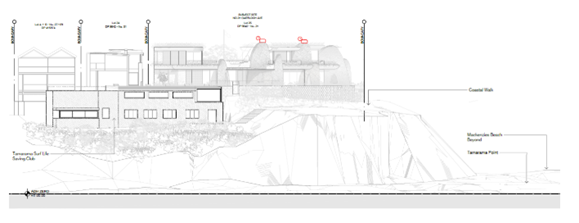
Southern Elevation – prepared by Mr Paul Walker, urban design expert
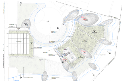
Site plan showing the roof (green), cocoons (grey ovals), and solarium court (circle top left)